Leen Helmink Antique Maps & Atlases
www.helmink.com
Jodocus Hondius I
CHINA
Certificate of Authentication and Description
This is to certify that the item illustrated and described below is a genuine antique
map, print or book that was first produced and published in 1606, today 420 years ago.
January 16, 2026
Cartographer(s)
Jodocus Hondius I
First Published
Amsterdam, 1606
This edition
1606 first edition (Latin)
Size
33.9 x 45.6 cms
Technique
Copper engraving
Stock number
18865
Condition
mint


Description
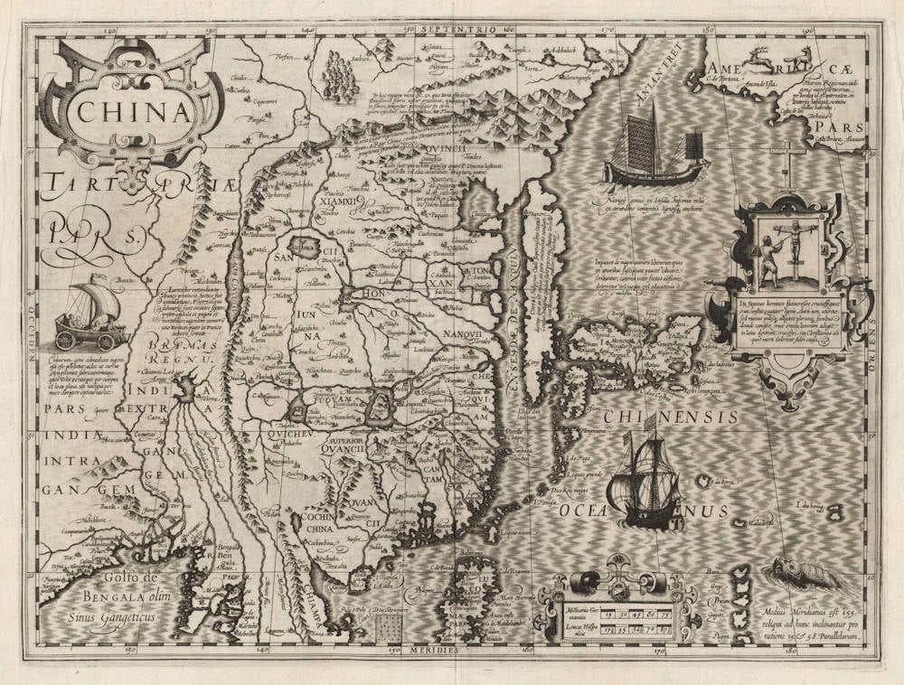
The geography is based on Cornelis Claesz wall map of Asia in eight sheets of 1602, and so is the Japanese crucifiction of the Jesuits shown in the panel next to Japan.
The ship north of Japan is copied from Oliver van Noort's 1602 journal of his circumnavigation. It was the first encounter of the Dutch with a Champan, and Van Noort and his crew were quite impressed. The journal reads:
"On the third of December while we were at anchor [outside Manila Bay], we became aware of a big sail on the horizon. The yacht [Eendragt] met them and brought their captain and some of the officers to our admiral [Mauritius]. It was one of the ships from Japan, of which the Chinese captain had told us. They were mostly carrying iron and flour which they load in Japan and come to Manila to sell. Their ship was about 50 last in size and had left Japan 25 days ago, accompanied by three other ships that the lost sight of in a tempest. The ships are of a very strange design. The front is flat like a chimney. The sails are made of reed mats, they have wooden anchors, and the cordage is made of straw. They are very skillful in sailing them."
(Van Noort, our translation)
The ship south of Japan is Van Noort's admiral ship Eendragt.
Collecting antique maps
A boldly engraved map showing Korea as an island, and combining elements of Barbuda's map of China and Texeira's map of Japan (both published earlier by Ortelius).
Amongst the decorative features a sea monster, deer on the North American coast, Dutch and Japanese ships, and a Chinese wind-blown land- vehicle can be seen. A scene in a panel on the right shows an ancient Japanese torturing technique [actually shown is the crucifixion of Christians].
The Mercator/Hondius/Jansson series of atlases was published in various European language versions. Although the face of the map remains constant the text on the reverse is, of course, translated and provides a fascinating insight into early European information of foreign and exotic countries. The text for this map describes the climate, national features, inhabitants and economy of China [ verbatim from the 1636 english edition ]:
'In every Mechanick art, and manifacture they are so exceeding skillfull and cunning, that their wockemanship seemeth rather to be made by nature, then by the hand of men... The Portugalls report many straynge things of the subtilitie of their spirits, among the rest, which is most to be wondered at, they have wind-chariots or wagens with sailes and know how to steere and governe them with such dexteritie, that in a short time they can carrie themselves where they please...'
(Potter).
Jodocus Hondius (1563-1612)
Jodocus Hondius the Younger (son) (1594-1629)
Henricus Hondius (son) (1597-1651)
Jodocus Hondius the Elder, one of the most notable engravers of his time, is known for his work in association with many of the cartographers and publishers prominent at the end of the sixteenth and the beginning of the seventeenth century.
A native of Flanders, he grew up in Ghent, apprenticed as an instrument and globe maker and map engraver. In 1584, to escape the religious troubles sweeping the Low Countries at that time, he fled to London where he spent some years before finally settling in Amsterdam about 1593. In the London period he came into contact with the leading scientists and geographers of the day and engraved maps in The Mariner's Mirrour, the English edition of Waghenaer's Sea Atlas, as well as others with Pieter van den Keere, his brother-in-law. No doubt his temporary exile in London stood him in good stead, earning him an international reputation, for it could have been no accident that Speed chose Hondius to engrave the plates for the maps in The Theatre of the Empire of Great Britaine in the years between 1605 and 1610.
In 1604 Hondius bought the plates of Mercator's Atlas which, in spite of its excellence, had not competed successfully with the continuing demand for the Ortelius Theatrum Orbis Terrarum. To meet this competition Hondius added about 40 maps to Mercator's original number and from 1606 published enlarged editions in many languages, still under Mercator's name but with his own name as publisher. These atlases have become known as the Mercator/ Hondius series. The following year the maps were re-engraved in miniature form and issued as a pocket Atlas Minor.
After the death of Jodocus Hondius the Elder in 1612, work on the two atlases, folio and miniature, was carried on by his widow and sons, Jodocus II and Henricus, and eventually in conjunction with Jan Jansson in Amsterdam. In all, from 1606 onwards, nearly 50 editions with increasing numbers of maps with texts in the main European languages were printed.
(Moreland and Bannister)