Leen Helmink Antique Maps & Atlases
www.helmink.com
Pierre Du Val
Novveau Mexique
Certificate of Authentication and Description
This is to certify that the item illustrated and described below is a genuine antique
map, print or book that was first produced and published in 1660, today 366 years ago.
July 31, 2026
Cartographer(s)
Pierre Du Val
First Published
Paris, 1660
This edition
1663
Size
10.0 x 12.5 cms
Technique
Copper engraving
Stock number
18816
Condition
excellent
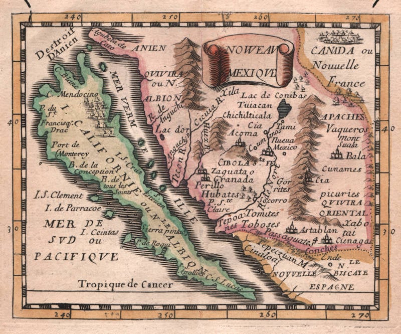
Description
Duval's very rare map of New Mexico, with Californiua as an island and the American southwest. The map shows many mythical places, including the legendary Strait of Anian and the Cities of Cibola, as well as Francis Drakes's landing place and New Albion. "Canada or New France" in the upper right. State 2 of 4.
Burden 353, as follows:
NOVVEAVI MEXIQVE
Copperplate engraving, 100 x 125 mm.
From: Le Monde Terrestre
This is one of a number of North American related maps in Pierre Duval's modest Le Monde Terrestre. It is derived from his uncle, Nicolas Sanson's, Audience de Guadalajara, 1657. One difference is the presence of Destroit D’Anien, and various unnamed mountain ranges. For a more detailed description of the atlas see the earlier Duval entry of 1659 [60]. The author has identified four states. There is a later derivative published in Nuremberg, 1678:
State 1 1660
The island of California lacks nomenclature. In the lower right is N.LE ESPAGNE
State 2 1663
In the lower right NOVVELLE ESPAGNE and much new nomenclature
State 3 1672
In the lower right NOVVELLE ESPAGNE ou= MEXIQVE
State 4 c.1687
The plate number 11 is added to the lower right corner
Duval 1660
Entitled NOVVEAV MEXIQVE
Beer 1678
Entitled NOVA MEXICO
(Burden 353)
Pierre Du Val (c.1619-1683)
Pierre Du Val was one of the most influential French mapmakers of the third quarter of the seventeenth century. He was the son-in-law and apprentice of Nicolas Sanson, the foremost French mapmaker of the period. From 1650, he was the official royal Geographer to the King of France Louis XIV, who had encouraged him to move to Paris. He published a wide range of atlases, individual maps of the world and the continents, as well as wall maps. His work was of great significance.