Leen Helmink Antique Maps & Atlases
www.helmink.com
Johannes van Loon
Pas-caerte van TERRA NOVA
Certificate of Authentication and Description
This is to certify that the item illustrated and described below is a genuine antique
map, print or book that was first produced and published in 1661, today 365 years ago.
July 31, 2026
Cartographer(s)
Johannes van Loon
First Published
Amsterdam, 1661
This edition
1668
Size
42.7 x 53.8 cms
Technique
Copper engraving
Stock number
18770
Condition
excellent
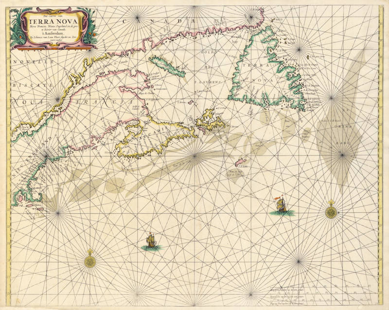
Description
The earliest Dutch Sea chart of New England and the Canadian Maritimes.
Johannes van Loon's very rare and important sea chart of the Northern part of America, with Hudson Bay, Davis Straits, Button Bay and the North West Passage. The first sea chart of the region. It became the prototype of the region for the rest of the 17th century. All charts by Joannes van Loon's Sea Atlas are of exceptional rarity.
"This uncommon prototype map appeared in the first edition of Joannes and Gillis van Loon's 'Zee Atlas'. In the same year, 1666, Pieter Goos published his 'Zee Atlas'
It is the earliest Dutch sea chart of the Maritimes. It is derived from numerous sources, amongst them Blaeu, Champlain, Sanson, and the manuscripts of Gerritsz.
Some English knowledge, noticeably of the Avalon Peninsula in Newfoundland, is not employed, even though utilised by Blaeu. Reliance on the latter leads to the omission of Prince Edward Island. The outline of the Grand Banks is drawn from Champlain”
(Burden 365)
Johannes van Loon (1611-1686)
Joannes van Loon was an accomplished mathematician and astronomer. His first cartographic involvements were with Theunis Jacobsz during the 1640s. From 1650 he worked with Joannes Janssonius, engraving amongst other worksthe plates for his Celestial Atlas by Cellarius, 1660.
In 1661 he published his first work with his brother, Gillis; the 'Zee Atlas' contained thirty-five maps. In 1666 the plates were Jan Jansson van Waesberge, with whom he then co-published the atlas. This edition was expanded to forty-seven maps, and by 1676 there were fifty.
(Burden)