Leen Helmink Antique Maps & Atlases
www.helmink.com
Pierre Du Val
Planisphere, ou Carte Generale du Monde.
Certificate of Authentication and Description
This is to certify that the item illustrated and described below is a genuine antique
map, print or book that was first produced and published in 1666, today 360 years ago.
July 14, 2026
Cartographer(s)
Pierre Du Val
First Published
Paris, 1666
This edition
1676
Size
33.0 x 59.0 cms
Technique
Copper engraving
Stock number
18754
Condition
excellent
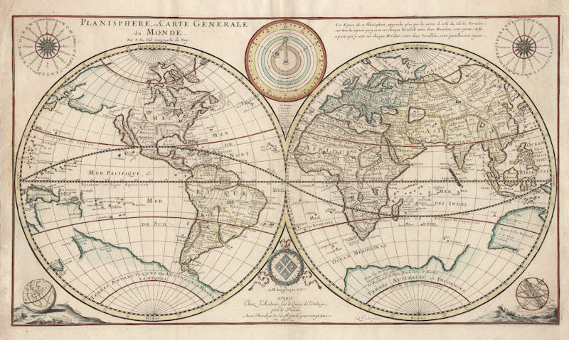
Description
Important early world map with the latest discoveries by the Dutch. The map is significant for the exploration of Australia, being one of the first to include the discoveries of Tasman's first voyage of 1642/43, albeit very confused and inaccurate. It curiously lacks the results of Tasman's second voyage of 1644, leaving open the possibility that the Gulf of Carpentaria or Torres' Strait allows for a gateway to the Pacific Ocean and the riches of Peru, one of the major goals of the VOC.
"In line with French tradition Du Val and his engraver Louis Cordier have eschewed extraneous decoration in this world map. The two hemispheres generally follow Sanson's latest world map of 1660 except for the unusual, and less accurate, representation of Australia. Du Val has also retained a prominent southern continent. In these respects the world map is outdated, as in the same 'Introduction' the author's map of the East Indies (dated 1665) gives a much more precise and accurate rendering of Australia, as then known.
Outside the hemispheres, at the top there are circular diagrams showing the compass points, winds and planetary orbits: in the bottom corners a small terrestial globe and an armillary sphere.\
There was a second state of the map dated 1668 and a third dated 1676 [offered here]. A new plate appeared in 1684, similar in design and content, with the imprint of Mlle du Val, Pierre's daughter."
(Shirley 441).
Pierre Du Val (c.1619-1683)
Pierre Du Val was one of the most influential French mapmakers of the third quarter of the seventeenth century. He was the son-in-law and apprentice of Nicolas Sanson, the foremost French mapmaker of the period. From 1650, he was the official royal Geographer to the King of France Louis XIV, who had encouraged him to move to Paris. He published a wide range of atlases, individual maps of the world and the continents, as well as wall maps. His work was of great significance.