Leen Helmink Antique Maps & Atlases
www.helmink.com
Pedro de Vera
Descripcion del Puerto de Los Olandeses en Ysla Hermosa
Certificate of Authentication and Description
This is to certify that the item illustrated and described below is a genuine antique
map, print or book that was first produced and published in 1626, today 400 years ago.
June 13, 2026
Cartographer(s)
Pedro de Vera
First Published
Manila, 1626
This edition
Taiwan, 1935
Size
74 x 80 cms
Technique
Pen, ink, watercolour
Stock number
18700
Condition
excellent
Description
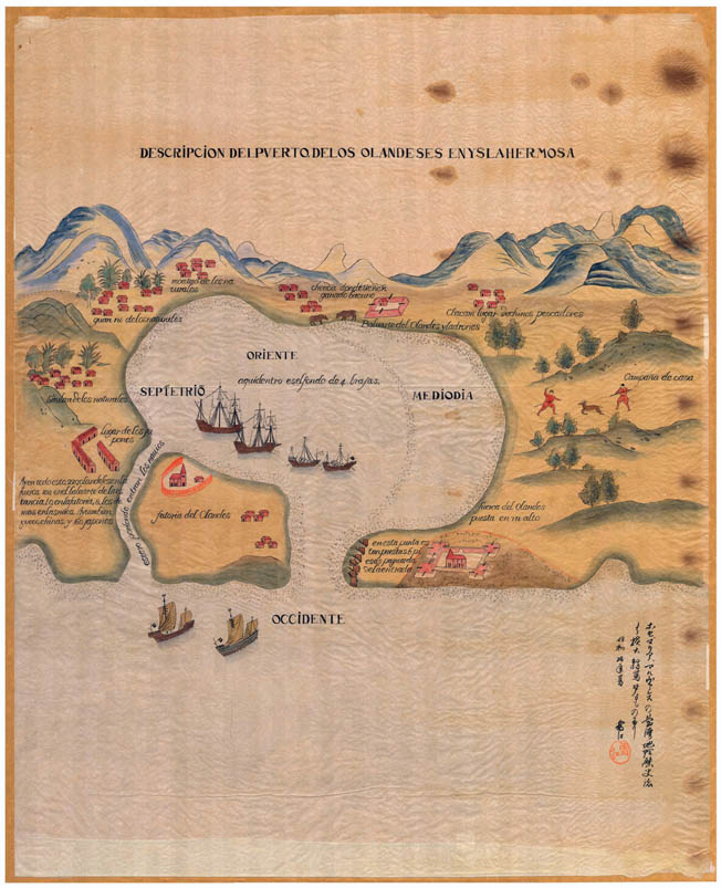
Unique 1935 manuscript copy of the first map and image of 1626 of Fort Zeelandia, two years after it was founded by the Dutch.
A large showpiece ideal for exhibitions.
Descripcion del Puerto de Los Olandeses en Ysla Hermosa
[ Description of the Harbour of the Dutch on the Island of Formosa ]
Pedra de Vera - Manila, 1626 / Yukie (Snow River) - Taiwan, 1935
Watercolour, 74 x 80 cm
On rice paper, 103 x 80 cm
Inscribed in Japanese calligraphy lower right, which translates:
This map is an enlarged copy from José Maria Alvarez’s Geography and History of Taiwan. Summer of the 10th year of Showa.
Showa period is from 1926 to 1989, so the tenth year of Showa is 1935. This map was painted in 1935 by the Japanese artist “Yukie” [Snow River]. With artist’s chop in orange ink.
This is an enlarged manuscript copy of the Spaniard, Pedro de Vera’s manuscript map which was painted in Manila in 1626. De Vera’s map was based on the notes of Salvador Diaz, a Chinese from Macau who was captured by the Dutch while on his way to Manila on board of the ship of Juan Batista, Inari, in 1622.
He was taken to and imprisoned in the Dutch fortress in the Pescadores Islands. In 1624 the Dutch moved to a port called Taiuan in the south west coast of Formosa where they built a new fortress named Zeelandia. Salvador went with the Dutch as a captive and lived there for two years.
In 1626 he escaped aboard a small fishing boat he had bought from local Chinese fishermen. Having worked for the Dutch as a translator he had many notes. When he returned to Macau he was able to give his notes to the Captain General on Chinese Territories, Francesco Mascarenhas. The view of Taiuan / Fort Zeelandia was originally painted in Manila in 1626. Salvador Diaz’ description of the Dutch fortress in Taiwan and his fascinating account of the activities of the Dutch, the Japanese and the Chincheos gave the picture much detail.
The original manuscript chart is in the Maritime Museum in Madrid, as part of a triplet of illuminated manuscript charts of Formosa, indexed as follows:
1626
Pedro de Vera.-
Tres cartas iluminadas:1. Isla Hermosa -Formosa-, parte de China y de la isla de Manila;
2. Puerto de los holandeses en la isla Hermosa;
3. Puerto de los españoles en la isla Hermosa
(Collección de manuscritos de Fernández de Navarrete, tomo XVIII, núm. 86, Ms. 270).
(Museo Naval de Madrid)