Leen Helmink Antique Maps & Atlases
www.helmink.com
Speed
The Kingdome of China
Certificate of Authentication and Description
This is to certify that the item illustrated and described below is a genuine antique
map, print or book that was first produced and published in 1626, today 400 years ago.
July 24, 2026
Cartographer(s)
Speed
First Published
London, 1626
This edition
1676
Size
51 x 39 cms
Technique
Copper engraving
Stock number
18689
Condition
mint
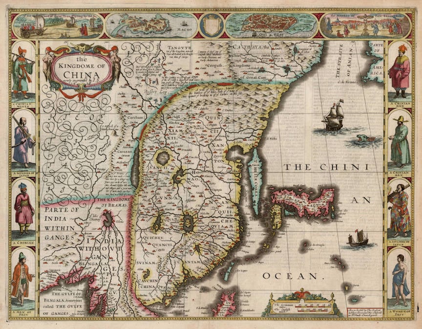
Description
The most decorative map of China, and the only one with figured borders. The geographical content is after the 1606 China map by Jodocus Hondius.
"This rare early map of China by English mapmaker John Speed, was published in his world atlas 'A Prospect of the Most Famous Parts of the World' (1627-1676), the first world atlas by an Englishman. The maps in this atlas took as their model the Dutch 'carte-a-figures' maps of the period and included decorative border vignettes. The map's vignettes include views of the cities of Quinzay (Hangzhou) and Macao along the top border, along with wind carts and the persecution of Christians in Japan. The side borders illustrate Speed's vision of the inhabitants of China and Japan.The Japanese soldiers are possibly the first such representations on a European map. The map includes Korea as an elongated island and Japan on the Ortelius-Texeira model. The view of Macao is a fine bird's eye view copied from de Bry."
(Barron).