Leen Helmink Antique Maps & Atlases
www.helmink.com
Bordone
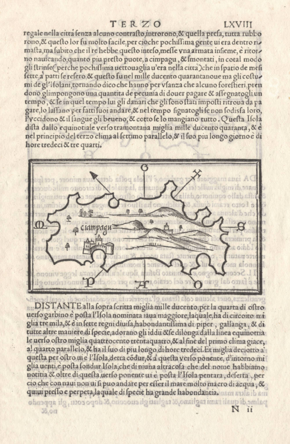
No title [ "ciampagu" in map ]
Certificate of Authentication and Description
This is to certify that the item illustrated and described below is a genuine antique
map, print or book that was first produced and published in 1528, today 498 years ago.
June 21, 2026
Cartographer(s)
Bordone
First Published
Venice, 1528
This edition
1534
Size
8.4 x 14.5 cms
Technique
Woodcut
Stock number
18674
Condition
excellent
Description
The first map of Japan, based on the hearsay account of Marco Polo. It's existence was doubted by many cartographers until it was rediscovered by the Europeans when first Portuguese ships arrived in 1543.
Ciampagu
- No scale bar.
- Venice : Benedetto Bordone, 1528).
- From: Libro Di Benedetto Bordone... Terzo, LXVIII.
- Woodcut; 8.5 x 14.5 cm.
- No latitude and longitude coordinates.
- Northeast at the top.
This is the earliest printed map known to be dedicated exclusively to Japan. A similar representation of the Japanese mainland off the coast of China, with different orientation, was published in L. Fries's edition of Ptolemy's Geographia... printed in Strasbourg in 1522. The map is a fanciful depiction, based on the relation of Marco Polo, as no Europeans had visited Japan at that time, the earliest contact not taking place until 1543.
The map is oriented exactly opposite to the true orientation of the main Japanese island of Honshū, with the north-east (Greco) at the top. The compass points, reading in a clockwise direction, are (other than North, shown as an arrow point) indicated by the first letter of each of the wind names: Levante (E), Scirocco (SE), Ostro, (S), Africus (SW), Ponente (W), and Maestro (NW). The only placename on the map is ciampagu, one of the many corruptions of the Chinese jihpen-kuo or, indifferently, Cipango, Cipangu, Zipangu, Zinpangri, and so on.
(Hubbard)
Benedetto Bordone (1460-1539)
Born in Padua, Bordone trained as an “illuminator and wood-engraver, working in Venice where, in 1508, he was given permission by the Senate to print maps of Italy and the world. No copies of these maps seem to have survived and he is known, therefore, only for his Isolario, printed in Venice in 1528.
Although issued as an ‘Island Book’ it gave prominence to discoveries in the New World and contained three full-size woodcut maps: the World, on an oval projection probably devised by the Florentine engraver, Francesco Rosselli, a map of Europe as a whole, and one of Greece and the North-Eastern Mediterranean. The remainder, about 80 woodcuts, are small maps or ‘charts' set in the text of the book,
(Moreland & Bannister).