Leen Helmink Antique Maps & Atlases
www.helmink.com
Waldseemüller
Tabula Moderna Indiae
Certificate of Authentication and Description
This is to certify that the item illustrated and described below is a genuine antique
map, print or book that was first produced and published in 1513, today 513 years ago.
July 8, 2026
Cartographer(s)
Waldseemüller
First Published
Strassburg, 1513
This edition
1513 first edition
Size
51 x 54 cms
Technique
Woodcut engraving
Stock number
18665
Condition
mint
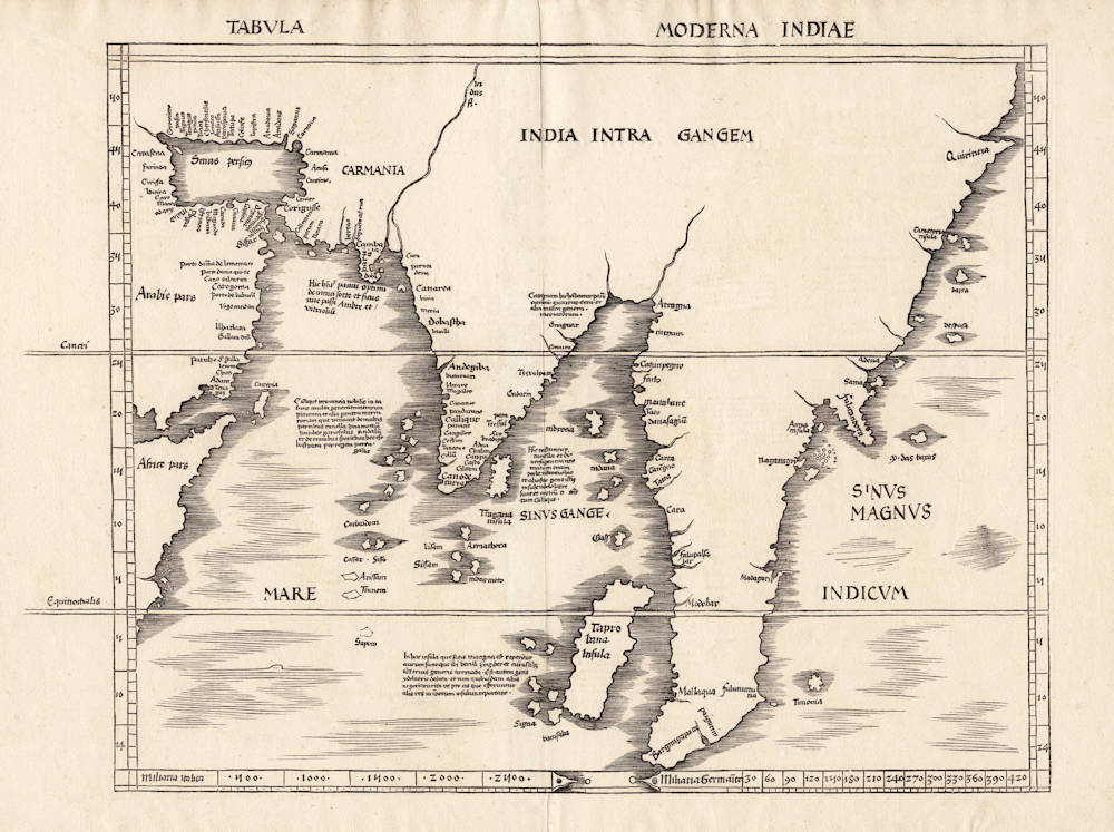
Description
The first modern map devoted to Asia. Attributed to Vasco da Gama, the first European to round the Cape of Good Hope in 1497-99, thereby opening a new sea route to trade with Asia.
"[The map is] evidently based on surveys undertaken during the two first voyages of Vasco da Gama"
(Nordenskiöld).
Martin Waldseemüller (c.1475-c.1522) was the geographer behind one of the early schools to study cartography, that at St. Die. He was the author of the wall map of 1507 which named America for the first time. In that same year it is believed he completed the maps for an edition of Ptolemy's 'Geography', it was not until 1513 though that it was published. Waldseemüller's maps are amongst some of the most sought after of the Ptolemy editions. Printed by Joannes Schott it is famous for including twenty modern or non-Ptolemaic maps.
This map of Asia is one of the highlights of the work. The cartography can be seen to derive from the portolan world map by Nicolo Caveri (Caverio) dated c.1505 and surviving today in the Bibliotheque Nationale, Paris. Although he states Genoa on the map it is believed that was his origin, not where the map was produced. This it is believed was made in Portugal, based on the fact that much of the nomenclature is Portuguese, that many Italian cartographers were working there at the time and the fact that its cartography is closely derived from the earliest confidently dated portolan to depict America; the Alberto Cantino of 1502. We know quite confidently of the origin of the Cantino as Burden states
'The return of two of Gaspar's vessels to Lisbon in the autumn of 1502 was witnessed by Alberto Cantino, an Italian diplomat in the employ of the Duke of Ferrara. At the latter's request, he had an unknown cartographer clandestinely make a beautiful world map. Preserved today in the Biblioteca Estense, Modena, Italy, Cantino personally carried it to Genoa in November 1502, where it was entrusted to be sent on to the Duke. It remained in the house of Este, in Ferrara, until 1592 when the entire library was transferred to Modena after Pope Clement VIII stripped Cesare d'Este of his duchy.'
This fascinating product of espionage has just as interesting a story to tell about its rediscovery.
'At some point it was used to cover a screen. Unfortunately to achieve this a strip was removed from the top. This appears to have contained some kind of title, as the remains of some of the descender characters can still be seen.
The map was stolen from the palace during a populist outbreak in 1859. A few years later Signor Boni, the librarian of the Biblioteca Estense, happened to pass a pork butcher's shop in the Via Farini where it was still being used as a screen. He bought it, removed it from the screen, and presented it to the Este Library' (Burden).
It is the Caveri map which Waldseemüller is believed to have seen and worked from. This is particularly seen by the fact that it extends further eastwards than the Cantino. Dominating the continent is 'India Intra Gangem' or India within the Ganges. The map displays a portion of the Arabian peninsula in the west including the entire Persian Gulf. The region represented by modern day Iran is named Carmania, an ancient Greek term for a province of the Achaemenid Empire. The prominent Indus River separates it from the recognisable Indian peninsula. Both the Maldives and Sri Lanka can be readily identified offshore.
There has been considerable debate on the use of the term Taprobana and its use for Ceylon (Sri Lanka) and or Sumatra which we won't go into here. One of the major representations here is of an open Indian Ocean against the belief of Ptolemy who believed it to be closed. The Portuguese at this time had reached India and were setting their sights on apparently ever greater riches further east.
In 1511 they captured Malacca clearly identified on the map near the tip of the peninsula. Suarez describes this portion of the map identifying 'Maitbane' as Martaban, a port at the mouth of the Salween River in Burma. 'Nagaragoy' is Lugor or Nakhon si Thammarat in southern Thailand. Caveri described the region here as bearing 'rubies and other stones of great value'. He states that the peninsula 'is in fact a first attempt to map 'true' Malaya and Indochina, and was probably extrapolated in large part from Arabic textual sources. Some of the nomenclature on the map agrees with Islamic navigational texts'. He goes on to cite the example of 'Timonia' (Pulau Tioman) off the south eastern shore which was not known to the Portuguese at the time but was a regular port of call for Arab and Malay traders since at least c.850.
At the tip of the peninsula is found 'Bargimgapara' or Singapore. Suarez describes the words corruption as coming from 'bahr Singarpura', 'bahr' being the Arab word for land. The earliest known Portuguese reference to Singapore is in a letter to Albuquerque in 1513. It is here as has been demonstrated that Portuguese awareness stops and early cartographers had to rely on the even earlier writings of the likes of Marco Polo. At the north east tip of the south east Asian peninsula can be seen a further smaller one entitled 'fulicandora', this represents what we know of as Indochina.
Literature: Burden (1996-2007) pp. xix-xxii; Karrow (1993) 80/47; Nordenskiold (1979) 205 no. 43; Pastoureau (1984) Ptolemee A; Shirley (2004) T.Ptol-6a; Suarez (1992) pp. 82-114.
(Burden)
Martin Waldseemüller (c.1470-1518)
Waldseemüller, born in Radolfzell, a village on what is now the Swiss shore of Lake Constance, studied for the church at Freiburg and eventually settled in St Dié at the Court of the Duke of Lorraine, at that time a noted patron of the arts. There, in the company of likeminded savants, he devoted himself to a study of cartography and cosmography, the outcome of which was a world map on 12 sheets, now famous as the map on which the name “America’ appears for the first time. Suggested by Waldseemüller in honour of Amerigo Vespucci (latinised: Americus Vesputius) whom he regarded, quite inexplicably, as the discoverer of the New World, the new name became generally accepted by geographers before the error could be rectified, and its use was endorsed by Mercator on his world map printed in 1538. Although only one copy is now known of Waldseemüller's map and of the later Carta Marina (1516) they were extensively copied in various forms by other cartographers of the day.
Waldseemüller is best known for his preparation from about 1507 onwards of the maps for an issue of Ptolemy's Geographia, now regarded as the most important edition of that work. Published by other hands in Strassburg in 1513, it included 20 ‘modern' maps and passed through one other edition in 1520. Four more editions on reduced size were issued of the Laurent Fries version.
It remained the most authoritative work of its time until the issue of Münster's Geographia in 1540 and Cosmographia in 1544.
(Moreland and Bannister)