Leen Helmink Antique Maps & Atlases
www.helmink.com
Visscher
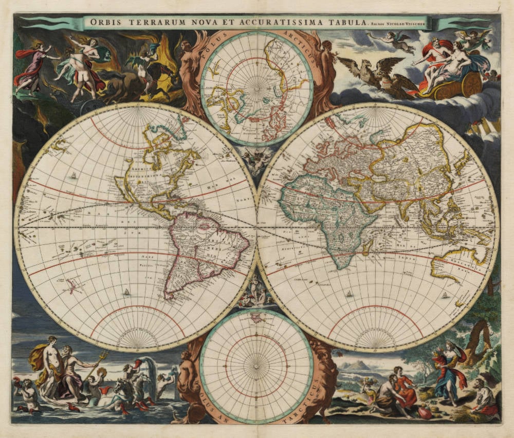
Orbis Terrarum Nova et Accuratissima Tabula
Certificate of Authentication and Description
This is to certify that the item illustrated and described below is a genuine antique
map, print or book that was first produced and published in 1658, today 368 years ago.
June 19, 2026
Cartographer(s)
Visscher
First Published
Amsterdam, 1658
This edition
1658
Size
47 x 56 cms
Technique
Copperplate engraving
Stock number
18663
Condition
excellent
Description
Beautiful and iconic double hemisphere map of the world, decorated with spectacular allegories of the four elements from classical antiquity, earth, air, water and fire. One of the earliest obtainable maps to show the Tasman discoveries.
Condition
Dark and even imprint of the copperplate. Thick paper with wide margins all around. Stunning contemporary color, applied by the Visscher publishing house at the time of production of the atlas. Excellent collector's condition.
"NICOLAAS VISSCHER's new world map in two hemispheres can be regarded as the master forerunner of a number of highly decorative Dutch Wond maps produced throughout the remainder of the century Essentially based on Blaeu's large world map of 1648. Visscher and his copiers introduced no major new geographical features. There were now minor variations in the still unknown coastline of North America, the northern part of California (as an island) has been flattened and is now entitled Nova Albion: still further north a small piece of land or an island Anian appears adjacent to a strait leading within striking distance of the west shores of Hudson's Bay. In China, stippling is used for the first time in a general map to denote a desert: this is the extensive Xamo Desertum (Xamo in Chinese meaning desert) just west of the Great Wall of China. The desert symbol was copied from M. Martini's Novus Atlas Sinensis published in 1655.
The distinctive attractiveness of many of the later seventeenth century Dutch world maps is to be found in their border decorations and Visscher's is no exception. His artist Nicolaes Berchem has introduced dramatic classical scenes representing the rape of Persephone, Zeus being carried across the heavens in an eagle-drawn chariot, Poseidon commanding his entourage, and Demeter receiving the fruits of the Earth. At the top and bottom are smaller spheres with projections based on the north and south poles; on the latter only the tip of South America can be seen."
(Shirley).
"In 1658, Nicolaas Visscher produced a new world map to replace the re-worked states of his father's 1614 world map. This new world map has been regarded by Shirley and others, as the forerunner of many of the highly decorative world maps (Shirley says 'master forerunner ...').
The geography of the map is essentially based on Joan Blaeu's 1648 wall map of the world. Australia and New Zealand are shown according to Tasman's first and second voyage discoveries in 1642-43 and 1644. Antonij van Diemens Landt is charted with Boreels Eylanden, Tasmans Eyl, West Eylanden and Vander Lints Eyl also shown. Other Dutch discoveries include those of Hartog in 1616, Houtman in 1619, the van Leeuwin discoveries in 1622, Carstensz's Cape York Peninsula discoveries in 1623, de Wit's in 1628 and Pieter Nuyts' in 1628.
The map also features two smaller polar projections of the world. America's north-west coast is uncharted and California is shown as an island with a blunt northern end named Nova Albion after Drake's landing there. Another feature of Visscher's map is the novel use of spotting to depict a desert area - that of Xamo Desertum in China."
(Dewez).
Claes Janszoon Visscher 1587-1652
Nicolaes Visscher I (son) 1618-1679
Nicolaes Visscher II (grandson) 1649-1702
Elisabeth Visscher (widow of N. Visscher II)
"For nearly a century the members of the Visscher family were important art dealers and map publishers in Amsterdam. The founder of the business, Claes Janszoon Visscher, had premises near to those of Pieter van den Keere and Jodocus Hondius whose pupil he may have been.
From about 1620 he designed a number of individual maps, including one of the British Isles, but his first atlas consisted of maps printed from plates bought from van den Keere and issued as they stood with some additions of his own, including historical scenes of battles and sieges for which he had a high reputation.
Some maps bear the latinized form of the family name: Piscator. After Visscher's death his son and grandson, both of the same name, issued a considerable number of atlases, constantly revised and brought up to date but most of them lacking an index and with varying contents.
The widow of Nicholaes Visscher II carried on the business until it finally passed into the hands of Pieter Schenk."
(Moreland & Bannister).