Leen Helmink Antique Maps & Atlases
www.helmink.com
Fries / Waldseemüller
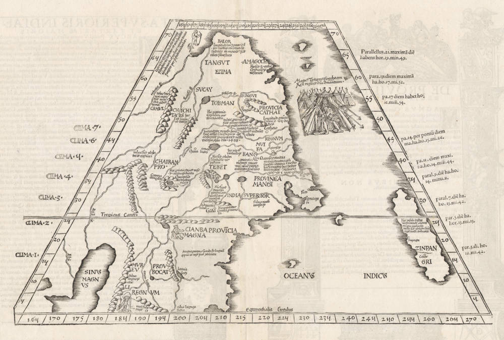
Ta. Superioris Indiae [on verso]
Certificate of Authentication and Description
This is to certify that the item illustrated and described below is a genuine antique
map, print or book that was first produced and published in 1522, today 504 years ago.
July 22, 2026
Cartographer(s)
Fries / Waldseemüller
First Published
Strassburg, 1522
This edition
Vienne, 1541
Size
29.0 x 45.5 cms
Technique
Woodcut
Stock number
18651
Condition
mint
Description
Wonderful woodcut map of China and Japan by Laurentz Fries after Waldseemüller's 1507 world map, which was - for these regions - modeled after Martellus Germanus' 1490 and 1492 world maps and Martin Behaim on his 1493 globe).
This map is the earliest "modern" map dedicated to Japan and/or China. The geographical contents is derived entirely from the accounts of Marco Polo, and many quotations from Polo's book are placed on this map. Japan is shown as one single island named "ZINPANGRI" and two cities "Sympangri" and "Cobebe" (although Marco Polo gives no Japanese city names ...). A picture of the Great Khan is included. The map is contiguous to the map of South East Asia from the same work.
Marco Polo himself had not visited Japan, and his accounts are based on information that he got from the Chinese. In fact, many European scholars were sceptical about the Polean accounts, and the existence of Japan was not confirmed until 1542 when it was first sighted by Europeans. The Portuguese discovered it by accidence, when a ship was drifted in a storm.
"This trapezoidal format is typical of the maps that were derived from the text of Ptolemy's 'Geographia'. In fact, however, Ptolemy's view of the world only extended to 'Farther India'. Hence, Waldseemüller transferred the information on Tartary and Zipangri taken from Marco Polo and added it to Ptolemy's description of the world."
(Walter/Hubbard).
"The [Ptolemy] edition contains a general map by Laurentius Frisius [...] and two new maps of eastern Asia. [...]
Out of the three maps, not borrowed from the [Ptolemy] edition of 1513, the [...] map of the world by Laurentius Frisius is certainly an original work [...]. The other two maps are the 'Tabulae Moderna Indiae orientalis' and 'Tabula superioris Indiae et Tartariae Majoris'. A closer examination of these maps shows that they are still almost exclusively based on traditions from Marco Polo, and the globe of Behaim. They may indeed, to a certain extent, be considered as the first reproduction of this globe, so often referred to in modern geographical literature."
(Nordenskjöld).
"The first post-Ptolemaic map of the Far East and a much overlooked map, being of considerably more significance, importance and influence in the early European cartography than often credited.
Originally published by Laurent Fries in the 1522 Strasburg edition of Claudius Ptolemy's 'Geographia', and reissued in subsequent editions of 1525, 1535 and 1541, this map forms one of the first 16th Century maps to update Ptolemy's cartographic concepts of the Far East and reconcile them with the influential account of the 13th Century Venetian traveller Marco Polo. Polo had been the first European [that reported] to reach the court [in Peking] of the Mongol Kublai Khan in 1275. He was also the first European to describe Japan or 'Zipangu', which he identified as a single island off the coasts of China.
The cartography of the classical scholar Ptolemy [Alexandria, AD 150] barely extended beyond the Malay Peninsula or 'Golden Chersonense' with the Indian Ocean landlocked at its eastern perimeters. This map reflects contemporary theories, including those of Columbus, as to the configuration of the Eastern coastlines of Asia. Most of the names are drawn verbatim from Polo's work. Japan is shown as a single island, a note indicating that it is an idolatrous country that does not pay tributes to the Chinese Khan. A fine portrait of the Kublai Khan, enthroned in stylised European splendour in a tented encampment appears top right."
(Barron).
The text legends on the map
For detailed transcriptions and translations of the Latin text legends on this map, as well as the sources for them, please contact us.
Laurent Fries (c.1490-c.1532)
Laurent Fries (Laurentius Frisius), born in Mulhouse in Burgundy, travelled widely, studying as a physician and mathematician in Vienne, Padua, Montpellier and Colmar before settling in Strassburg. There he is first heard of working as a draughtsman on Peter Apian's highly decorative cordiform World Map, published in 1520. Apian’s map was based on Waldseemüller's map of 1507 which no doubt inspired Fries's interest in the Waldseemüller Ptolemy atlases of 1513 and 1520 and brought him into contact with the publisher, Johannes Grüninger. It is thought that Grüninger had acquired the woodcuts of the 1520 edition with the intention of producing a new version to be edited by Fries. Under his direction the maps were redrawn and although many of them were unchanged, except for size, others were embellished with historical notes and figures, legends and the occasional sea monster. Three new maps were added.
There were four editions of Fries' reduced sized re-issue of Waldseemüller's Ptolemy atlas:
1522 Strassburg: 50 woodcut maps, reduced in size, revised by Laurent Fries (Laurentius Frisius) and included the earliest map showing the name ‘America' which is likely to be available to collectors
1525 Strassburg: re-issue of 1522 maps
1535 Lyon: re-issue of 1522 maps, edited by Michael Servetus who was subsequently tried for heresy and burned at the stake in 1553, ostensibly because of derogatory comments in the atlas about the Holy Land – the fact that the notes in question had not even been written by Servetus, but were copied from earlier editions, left his Calvinist persecutors unmoved
1541 Vienne (Dauphiné): re-issue of the Lyon edition - the offensive comments about the Holy Land have been deleted
(Moreland and Bannister)
Martin Waldseemüller (c.1470-1518)
Waldseemüller, born in Radolfzell, a village on what is now the Swiss shore of Lake Constance, studied for the church at Freiburg and eventually settled in St Dié at the Court of the Duke of Lorraine, at that time a noted patron of the arts. There, in the company of likeminded savants, he devoted himself to a study of cartography and cosmography, the outcome of which was a world map on 12 sheets, now famous as the map on which the name “America’ appears for the first time. Suggested by Waldseemüller in honour of Amerigo Vespucci (latinised: Americus Vesputius) whom he regarded, quite inexplicably, as the discoverer of the New World, the new name became generally accepted by geographers before the error could be rectified, and its use was endorsed by Mercator on his world map printed in 1538. Although only one copy is now known of Waldseemüller's map and of the later Carta Marina (1516) they were extensively copied in various forms by other cartographers of the day.
Waldseemüller is best known for his preparation from about 1507 onwards of the maps for an issue of Ptolemy's Geographia, now regarded as the most important edition of that work. Published by other hands in Strassburg in 1513, it included 20 ‘modern' maps and passed through one other edition in 1520. Four more editions on reduced size were issued of the Laurent Fries version.
It remained the most authoritative work of its time until the issue of Münster's Geographia in 1540 and Cosmographia in 1544.
(Moreland and Bannister)