Leen Helmink Antique Maps & Atlases
www.helmink.com
Plancius
Orbis Terrarum Typus De Integro Multis in Locis Emendatus
Certificate of Authentication and Description
This is to certify that the item illustrated and described below is a genuine antique
map, print or book that was first produced and published in 1594, today 432 years ago.
July 31, 2026
Cartographer(s)
Plancius
First Published
Amsterdam, 1594
This edition
Size
40.5 x 57.5 cms
Technique
Copper engraving
Stock number
18604
Condition
pristine
Description
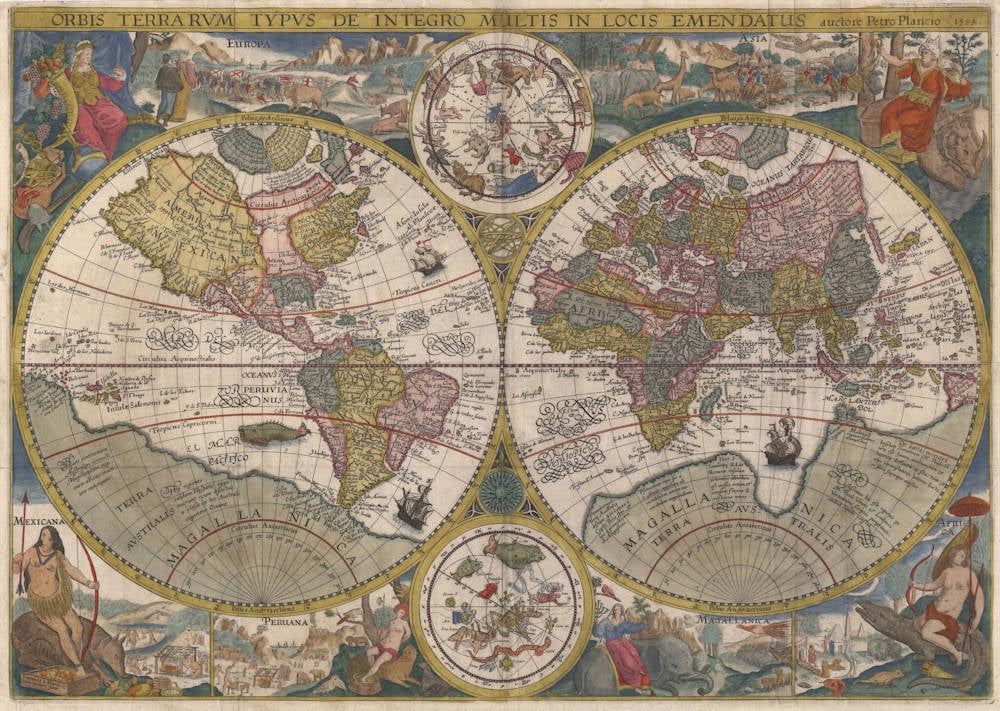
The Mapping of the World
This new world map by Petrus Plancius was first issued separately in 1595 or shortly thereafter and then later incorporated into editions of Linschoten's Itinerarium from 1599 onwards. It has been engraved by Jan van Doetecum, a craftsman of great skill whose signature appears in the lower left-hand corner and who was associated with a number of Plancius' maps.
The two main terrestial hemispheres are based on those in Plancius' earlier world map of 1590, updated by geographical detail and with the addition of two celestial spheres from his large wall map two years later. The Far East, in particular, is more accurately represented. Korea appears as a peninsula for the first time and Plancius shows an improved outline for Japan, based on drawings by the Portuguese cartographer Luiz Teixeira. New Guinea, an island in the earlier maps, is however now joined to the extensive southern continent named Magellanica.
Inscriptions in the arctic show that Plancius was aware of reports of English voyages there and, perhaps to encourage forthcoming expeditions, Novaya Zemlaya is newly shown as an island. Koeman, writing in his introduction to Jodocus Hondius' Wall-Map of Europe 1595 (Amsterdam, 1967) says of Plancius' map that 'Some copies show traces of the correction of an earlier edition in which the Arctic continent has been revised in order to depict the islands of Novaya Zemlaya'. I have not seen an unrevised state, and it is usually accepted that Barentsz.' voyages of 1594 were first portrayed on the twin hemispheres which Hondius portrayed on his large map of Europe the following year, 1595.
The elaborate pictorial borders were inspired by drawings in the works of Theodore de Bry published a few years earlier and established a pattern of cartographical decoration that lasted over a century. The regions of the world are exemplified by means of symbolic female figures, by landscape vignettes, and by lively pictures of animals indigenous to each area. Doetecum has included elephants and camels, a giraffe, a unicorn, an ostrich and the footless bird of paradise; parrots, snakes and monkeys and - as unlikely beasts of transport for the regional figures - a rhinoceros, a crocodile and a giant armadillo. Europe and Asia are thus shown along the top of the map and Africa, Magellanica, Peru [South America] and Mexico [North America] along the bottom.
Plancius' map had a widespread influence on other map-makers and it was issued unchanged throughout the various editions of Linschoten's 'Itinerarium' from 1599 onwards. It is therefore occasionally available to collectors.
(Shirley)
Collecting Antique Maps
The first World Map with elaborate, pictorial borders.
This beautiful map from Linschoten's Voyages combines the skills of two of the most respected map makers and engravers of the day. Petrus Plancius and Jan van Doetichum, whose signature is visible at the lower left, worked together on many map productions and this is one of their best known.
This map is the first to use elaborate pictorial borders representing the peoples, animals and environment of foreign parts and established a tradition which was maintained by most Dutch map makers throughout the next century and by numerous others of various nations over the next two hundred years.
In each corner are female representations of the four continents: Europe, an elegant crowned figure holding a cornucopia and a sceptre, a helmet, a lute and symbols of wisdom at her feet; Asia, an elaborately robed figure seated on a rhinoceros and holding an incense burner, a casket of baubles at her feet; Africa, an almost naked figure riding a crocodile armed with bow and arrows; America, entitled Mexicana, an Amazon figure seated on an armadillo.
Between the figures and the celestial spheres at top and bottom are further illustrations of the animals, people and habitations of these exotic places. Much of the illustration here, as in numerous Dutch map design was inspired by the illustrations in the reports published by de Bry a few years earlier.
This map by Plancius was copied almost line-for-line by others but a few of the subsequent seventeenth-century World maps came close to matching this for a combination of content and decoration.
(Potter)
Antique Maps - A Colector's Guide
Similar maps of this two-hemisphere type, with elaborate pictorial borders inspired by Theodore de Bry's collection of travelers' tales, were popular for a century or more after Plancius introduced his 1594 map. It in turn was based on Mercator's two-hemisphere world map of 1587. The northern and southern celestial hemispheres came from Plancius's owm large world map of 1592. The changes Plancius made both to Mercator's map and to his own precursors of the 1594 map seen to have been introduced partly to make the idea of a sea route to Asia through the arctic appear more attractive, for Plancius was waging a personal campaign to promote Dutch penetration into Far Eastern markets.
The first Dutch landfall in Australia was not made until 1606, so that Magellanica was still filled with details drawn from the by then centuries-old stories of travelers like the Polos and Lodovico di Varthema; note Marco Polo's Lucach, Beach, and Maletur. Nevertheless, farther to the north Java, Borneo, and the Philippines are all recognizable, and in the arctic, an inscription indicates that Plancius paid close attention to reports of English voyages into the polar regions.
(Tooley & Bricker)
Petrus Plancius (1552-1622)
Born as Peter Platevoet in Flanders, Petrus Plancius studied abroad and became a theologian and a mapmaker.
He produced some globes and maps, including a well-known world map in 1592. He had a great influence on the Dutch Asian expeditions.
Early Years
Peter Platevoet was born in 1552 in the Flanders village of Dranouter. Little is known about his childhood, but it seems that his parents became Protestants. Platevoet studied theology, history, and languages in Germany and England. In England he probably learned about mathematics, astronomy, and geography. When he was older, Platevoet Latinized his name, as was the custom among savants at that time.
In 1576 he became a preacher in West-Flanders, a province in Belgium, and later that year he went to Mechelen, Brussels, and Louvain. In the 1580s he stayed in Brussels for a long time, but when the city surrendered to the duke of Parma, King Philip II of Spain’s governor-general in the Netherlands, in 1585 Petrus Plancius fled to the north. He lived in Amsterdam and became a pastor of the Dutch Reformed Church. From December 1585 until his death on 15 May 1622, he fulfilled his job as preacher. Plancius was a fervent Contra-Remonstrant and discussed many theological issues.
In addition to his thorough knowledge of the Holy Bible, he was well-grounded in the study of cosmography, geography, and cartography. He was not only one of the most talked-about preachers in the Dutch republic, but also one of the important mapmakers of his time.
Early Publications
Petrus Plancius was the first caert-snyder (map cutter) in the Dutch republic to produce waxed grid maps. Therefore, on 12 September 1594 he received a patent for the publication and distribution of the world map for twelve years from the States-General. He was, together with the Flemish engraver and map-maker Jodocus Hondius and the brothers Van Langren, one of the first makers of celestial globes in the Netherlands. His first globe was produced in 1589, a revision of an earlier celestial globe. Among his revisions were four additions to the southern sky: the two Magellanic Clouds (they were unnamed on the globe) and two new constellations, Crux and Triangulus Antarticus. Their positions were taken from reports of explorers.
In 1590 Petrus Plancius made five terrestrial maps for a Dutch edition of the Holy Bible. Two years later he made a well-known world map: Nova et exacta terrarum orbis tabula geographica ac hydrographica (New and exact geographical and hydrographical map of the world). This map contained celestial planispheres in the upper corners on which he added two additional constellations.
Asian Expeditions
Petrus Plancius was one of the driving forces behind the first Dutch expeditions to Asia, assisting with preparations and providing instruction. To avoid encounters with Spain and Portugal, which were already sailing to the East Indies around southern Africa, Plancius decided to try a northeast route around Asia. He supplied maps for the voyage and advised the fleet commander, Willem Barents, in celestial navigation. The northeast voyages of 1594 and 1595 were failures, but a third attempt was made in 1596. It was on that last expedition that Barents’s ship got stuck in the polar ice, and the crew had to spend the winter in Nova Zembla, an island northwest above Russia, in what came to be called the Barents Sea. Late in the spring of the next year, the crew was able to sail south in two small boats. Barents died on the return voyage; the survivors arrived at Amsterdam in November 1597, not having found a northeast passageway.
In 1595, together with Barents, Plancius published a book titled Nieuwe Beschrijvinghe ende Caertboeck van de Middelandtsche Zee (New description and map book of the Mediterranean Sea). In this work he designed a map that was engraved by the well-known globe- and map-maker Hondius.
Because the northeast sea route around Asia did not seem very promising, even before the third voyage a group of Dutch merchants had financed a southern expedition. Plancius again helped with the planning and used the opportunity to conduct scientific research. A theory in the late sixteenth century claimed that a compass needle’s variation from north (its declination) would enable one to determine longitude. Plancius developed his own theory to ascertain longitude at sea by means of magnetic variation. To test that theory during the southern voyage, Plancius taught junior merchant Frederik de Houtman how to measure and record compass declinations. It is known that the method developed by Plancius was used from 1596 onward by mariners.
Plancius also used the voyage to discover southern stars that were not visible from Europe. He taught navigators, especially Pieter Dircksz Keyser, but also other sailors, how to measure star positions with an astrolabe and instructed them to chart the southern sky. From ship records of 1596 it is known that the astrolabe was used to measure the declination of the southern stars.
The Dutch southern expedition, known as the Eerste Shipvaart, or First Voyage, set sail from the port of Texel in April 1595. It reached the East Indies in 1596 and returned to Texel in August 1597. Plancius asked Keyser, the chief pilot on the Hollandia, to make observations to fill in the blank area around the south celestial pole on European maps of the southern sky. Keyser died in Java the following year, but his catalog included 135 new stars arranged in twelve new constellations. Most of them were invented to honor discoveries by sixteenth-century explorers. They were first published on a 1598 celestial globe made by Hondius.
After the foundation of the VOC (Verenigde Oostindische Compagnie, or East India Company) in 1602, Plancius became its first mapmaker. During the first quarter of the seventeenth century, he seemed more interested in preaching than in cartography and cosmography. But still, some of his maps were published during that time. In 1607 he produced a large revised world map. In 1612 he created a celestial globe, and later he designed an Earth and another celestial globe (1614 and 1615), both brought out by the well-known publisher Petrus Kaerius. His contemporaries described him as one of the greatest geographers of his time.
Bibliography
A complete bibliography of Plancius’s work, with descriptions of much of his maps and publications, is Günter Schilder, Monumenta Cartographica Neerlandica, Vol. VII, Cornelis Claesz (c. 1551–1609): Stimulator and Driving Force of Dutch Cartography, Alphen aan den Rijn, Netherlands: Canaletto/Repro-Holland, 2003.
(encyclopedia.com)