Leen Helmink Antique Maps & Atlases
www.helmink.com
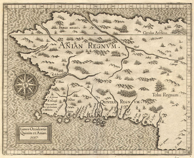
Wytfliet
Limes Occidentis Quivira et Anian. 1597.
Certificate of Authentication and Description
This is to certify that the item illustrated and described below is a genuine antique
map, print or book that was first produced and published in 1597, today 429 years ago.
July 31, 2026
Cartographer(s)
Wytfliet
First Published
Louvain, 1597
This edition
1597 first edition first state
Size
23.0 x 28.9 cms
Technique
Copper engraving
Stock number
18411
Condition
mint
Description
Cornelis Wytfliet's map of North-West America after Mercator, de Jode, Plancius and Gastaldi. The map includes Northern California with C. de S. Francisco, Tierra Brava, La Sierra Nevada, C. Medocino, etc. Marco Polo's Quivira, Anian and Tolm empires fill most of the region.
Limes Occidentis/ Quiuira et Anian./ 1597.
This is from the first atlas on America by Cornelis van Wytfliet. It is one of two maps that are of the west coast of North America. It covers the entire coastal portions of the present day United States and Canada. The general shape derives from that of Gerard Mercator's world map of 1569, with a pronounced bulge coincidentally similar to that of Alaska as we know it today, but latitudinally larger so that its south coast is at about 40 degrees.
It encompasses a similar area to the earlier Cornelis de Jode Quiviræ Regnu of 1593. However, this map only extends southwards to the latitude of 30°, not quite as far but it loses none of the coastline in the process. Longitudinally Wytfliet stretches the westward reach of the continent to almost 180°, 10° further than de Jode but not as far as Petrus Plancius in his world map of 1592. This latter map was the principal source of the nomenclature. Wagner discusses the possible sources of these in more detail. All of the coast above approximately C. Medocino was yet to be visited by Europeans and it was left to Captain James Cook, 180 years later, to first accurately chart these waters. South of this the Spanish had made a number of exploratory voyages starting in the 1530s.
At the top of the map above the Arctic Circle we find the by now familiar North West Passage. On a number of maps at this time various rivers are shown flowing north into these waters; no possible explanation can be given for this other than the assumption that in such a vast expanse of land there would be some.
ANIAN REGNVM stems from the strait separating the continent from Asia; it was so named by Giacomo Gastaldi in 1561. There are two states of the map:
State 1: 1597 Dated 1597
State 2: 1607 Date removed. No other alterations
All issues are without text on the back. There was a derivative map by Johannes Metellus, published in Cologne, 1598.
(Burden).
References
Burden 100-107. Koeman (1967) vol. 3, p. 219/ Nordenskiöld (1889) p. 133/ Lamb (1956) no. 747/ Phillips (1909-) no. 1140/ Skelton (1964)/ Wagner (1937) no. 189.
Condition
1597 first edition, first state. Pristine condition. Wide margins all around. No paper restorations or imperfections. Strong early and even imprint of the copperplate. Best possible collector's example.
Cornelis Wytfliet (?-1597)
Little is known of Wytfliet except that he was a native of Brabant, but there is no doubt about the importance of his only atlas, which was the first one printed to deal exclusively with America.
Although its title indicated to be a 'supplement to Ptolemy', Part I covered the history of the discovery of America and its geography and natural history and Part II consisted entirely of the contemporary maps of America and a world map based on Mercator.
(Moreland & Bannister).
Descriptionis Ptolemaicae Augmentum
In 1597 Cornelis van Wytfliet published his Augmentum to Ptolemy's Geography. This is true in as much as it covers all the Americas, a part of the world unknown to the latter; however, no other connection between them exists. Dedicated to Philip III of Spain it is a history of the New World to date, recording its discovery, natural history etc. For the book Wytfliet had engraved nineteen maps, by whom we do not know, one of the world and eighteen regional maps of the Americas. Of these the following eight maps all relate to the north of the continent. As such this book can be truly called the first atlas of America. It was an immediate success and ran to several editions. Not much is known about Wytfliet other than that he was an advocate and secretary to the Council of Brabant, whose capital at the time was Louvain.
Despite the fact that this map covers territory virtually unknown to the Europeans, it owes its existence to the fact that Wytfliet showed every part of the continent however little knowledge there was of it.
(Burden).
THE ATLAS OF AMERICA BY CORNELIS VAN WYTFLIET
The Descriptionis Ptolemaicae Augmentum (“Augmentation to Ptolemy's description”) is the only known work by Cornelis van Wytfliet, secretary to the Council of Brabant, who died in 1597 (a more correct Dutch orthography of his name is “Van Wijtvliet”). He named his work an augmentation to Ptolemy's Geography because it covers the Americas, a part of the world unknown to Ptolemy. However, there is no other connection between the works of Ptolemy and Van Wytfliet.
His book includes 19 maps, a world map and 18 regional maps, all of which were specially engraved for this edition. It was the first separately published atlas with all the maps entirely devoted to America. Most of Van Wytfliet's maps are the first or among the earliest of specific regions of North and South America. The accompanying text describes the geography, natural history and ethnography. It provides a history of exploration and the voyages of Christopher Columbus (1492-1502), John Cabot (1497-98), Sebastian Cabot (1526-28), Francisco Pizarro (1527-35), Giovanni de Verrazzano (1524), Jacques Cartier (1540-42), and Martin Frobisher (1576-78).
Two editions of the Descriptionis Ptolemaicae were published at Leuven in 1597 and 1598 respectively by Jean Bogard and Gerard Rivius. Jean Bogard was publisher in Douai in France (1574-86 and 1598-1616) and Leuven (1586-98; however, it is possible that the Leuven publisher in this period was Jean's son Jean II Bogard). In 1603 the first Douai edition was issued by François Fabri, who continued issuing various editions with Latin and French texts. The last edition of Wytfliet’s book was published in Arnhem, where Jan Jansz. issued an edition with a French text in 1615.
(van der Krogt)