Leen Helmink Antique Maps & Atlases
www.helmink.com
Blaeu
Nova Belgica et Anglia Nova
Certificate of Authentication and Description
This is to certify that the item illustrated and described below is a genuine antique
map, print or book that was first produced and published in 1635, today 391 years ago.
July 16, 2026
Cartographer(s)
Blaeu
First Published
Amsterdam, 1635
This edition
1664 Atlas Maior
Size
38.5 x 50.5 cms
Technique
Copper engraving
Stock number
17001
Condition
mint
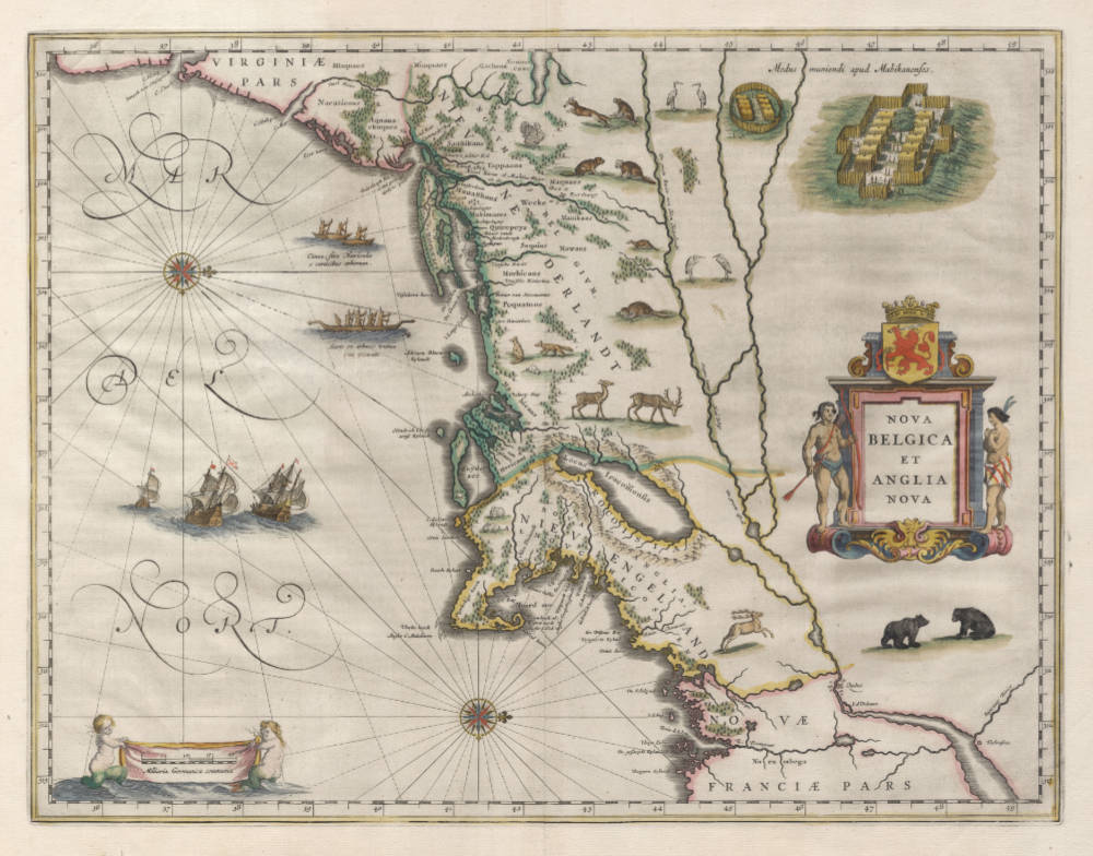
Description
"This most important map was one of the most attractive of the Americas at the time. It is noted for the fact that its primary source is the first manuscript figurative map of Adriaen Block, 1614. Indeed it is the first full representation in print. It is one of the earliest to name 'Nieu Amsterdam'. Block, a Dutch fur trader, explored the area between Cape Cod and Manhattan, examining the bays and rivers along the way. This helped to create an accurate picture of the longitudinal scale of the coastline. His manuscript map is the first to delineate an insular Manhattan; it also provides the earliest appearance of 'Manhates' and 'Niev Nederlandt'.
It has been noted that the time difference between 1614, the date of the manuscript, and Blaeu's map whose first appearance is in 1635, appears long for such an important advance. It would seem highly feasible that Blaeu, who published many separately issued maps, would have wanted to produce one like this sooner. However, evidence points to the fact that it could not have been made before 1630. The Stokes collection in New York possesses an example of the map on thicker paper without text on the reverse which could well be a proof issue of some kind.
There are features on Blaeu's map that differ from the Block chart. Some of these could be accounted for by the fact that the surviving figurative map is not original, and that the copiest omitted some placenames that are referred to in the text of de Laet's work. Block drew on Chaimplain's map of 1612 for the depiction of the lake named after him, but it is here called 'Lacus Irocoisiensis'. Blaeu does not appear to have updated this part of his map. The lack of interrelation between the Dutch or English colonies and the French, led for some time to the eastward displacement of this lake when its true position would be north of the Hudson River. Some nomenclature has its origins in Blaeu's second 'Paskaert' of c.1630, and others, such as 'Manhatthans', in de Laet. The colony of 'Nieu Pleimonth' is identified. This and other English names along this part of the coast are largely derived from Smith's 'New England', 1616.
Cape Cod is here improved over the Block manuscript by being reconnected to the mainland, the narrow strait having been removed. The coastline between here and Narragansett Bay, which can be clearly recognised, is not so accurate. 'Adriaen Blocx Eylandt' leads us to the 'Versche Rivier', or Connecticut River, which Block ascended as far as possible. 't Lange Eyland' is named; however, it is incorrectly too far east, being applied to what is possibly Fishers Island. 'De Groote bay' marks Long Island Sound. The Hudson River is still notnamed as such, but is littered with Dutch settlements, and the failed Fort Nassau is here depicted renamed as 'Fort Orange'. He does, however, improve on the direction of its flow. Blaeu separates the sources of the Hudson and Delaware Rivers which had been causing some confusion. 'Nieu Amsterdam' is correctly marked as a fort at the tip of an island separated on the east side by 'Hellegat', or the East River. The coastline south of Sandy Hook also shows signs of improvement.
The whole map is adorned by deer, foxes, bears, egrets, rabbits, cranes and turkeys. Beavers, polecats and otters appear on a printed map for the first time. The Mohawk Indian village top right is derived from the de Bry-White engravings.
The map survived through the remaining publishing history of the Blaeu house. Willem Blaeu himself died in 1638, and the business passed to his sons, Cornelis and Joan. The latter, particularly, carried the family name and was the driving force behind the multi-volume 'Atlas Major'. On 23 February 1672 a fire at the firm destroyed its cartographic production. Some plates were dispersed at auction but this map is not known to have been reissued."
(Burden).
"Oriented west to the top of the plate, this beautiful map of New England and the New Netherlands is one of the earliest detailed maps to include that part of North America colonised by the Dutch, and is the first printed map showing Indian canoes and several Noth American fauna such as turkeys, beavers, polecats and otters.
First produced by Willem Blaeu in 1635, it exercised considerable influence for many years. The geograpgical details were derived mostly from a manuscript map of the region drawn in 1614 by the Dutch explorer Adriaen Blockx (now in the Algemeen Rijksarchief at 's-Gravenhage), and from a map in Johannes de Laet's 'Nieuwe Wereldt' of 1630.
Blockx, a fur trader as well as an explorer, first arrived in North America in 1611 and set out on a coasting voyage in 1614. His ship, 'Onrust', was the first boat built on Manhattan Island. He sailed through the 'Hellegat' (East River) into 'De Groote Bay' (Long Island Sound) exploring the shores and noting the locations of the various tribes of Indians, such as the 'Manhattans', 'Morhicans', 'Pequatoos' and others. Note also the illustrations of pallisaded Indian villages, dug-out canoes and the male and female figures decorating the title cartouche.
Adriaen Blockx himself is commemorated by 'Adriaen Blocx Eylandt', nowadays known as Block Island, off the Rhode Island shore."
(Goss).
"West is at the top in this beautiful, highly prized map.
It is perhaps the earliest map to show both New England and the Dutch part of the region. It includes many very early depictions of native fauna, including wild turkey. It indicates the lands of several Indian tribes, such as the Manhattans.
Based on a manuscript map by Adriaen Blockx (after whom Block's Island is named), this was an important map for many years and influenced later maps in no small degree.
Note the misplaced Lake Champlain, and compare its location here to where it was put in a much later map by Homann [...].
There are Indian towns, surrounded by stockades and Indian boats.
There is text on the verso of most examples, and because of the large open areas of water, the map commonly has some degree of show-through."
(Manasek)
Condition
Pristine condition, from the prestigious Atlas Maior, the most expensive book of its day. A strong and even imprint of the copperplate. No paper restorations or imperfections. No paper discoloration. Gorgeous contemporary Atlas Maior coloring. The best imaginable collector's condition.
Willem Janszoon Blaeu (1571-1638)
Joan Blaeu (son) (1596-1673)
Cornelis Blaeu (son) (?-c.1642)
Willem Jansz. [Blaeu] and his son Joan are the most widely known cartographic publishers of the seventeenth century. Born as the son of a wealthy herring merchant in Alkmaar North Holland, to Anna, a first cousin of Willem. Cornelis Hooft was merchant in oil, grain and herring and twelve times mayor of Amsterdam. He hoped that Willem would take over his business.
But Willem was more interested in mathematics, astronomy and other scientific matters, however, and in 1595 he left for Denmark to study with the astronomer Tycho Brahe on the island of Ven. Brahe had established here his own observatory as well as a workshop for the manufacturing of instruments and a printing office. This enabled young Willem to acquire both theoretical and practical knowledge and provided him with contacts among like-minded people. After his return to the Netherlands he applied himself to astronomy for several years in his native Alkmaar. Here he published his first cartographic work: a celestial globe according to the observations of Tycho Brahe.
At the end of the sixteenth century Willem Jansz. moved with his family to Amsterdam. He set up a shop in celestial and terrestrial globes and nautical instruments, since the rapid growth of seafaring opened a large market for these goods. Soon he was able to offer for sale globes in various sizes. In 1605 Willem Jansz. moved to a new location at the "Op ‘t Water" (today Damrak nr. 46), a house with the sign of in de Vergulde Sonnewijwyser ("in the Gilded Sundial"). Apart from the manufacturing globes, Willem Jansz. published numerous maps and charts in folio size, along with multi-sheet wall maps, town views, and historical prints, all of which are now very rare.
Willem Jansz. made an unmatched contribution to the fields of navigation and cartography. His "Het Licht der Zee-vaert", published in 1608, was of great consequence for navigation in European coastal waters. He used the same oblong-size like Waghenaer did in his "Thresoor der Zeevaert" (1592): the work was constructed in a series of chapters, adding to each chapter sailing-descriptions for a specific stretch of coast and the corresponding chart. The coastal profiles in woodcut have been included in the text of each chapter.
In 1618 another mapmaker, bookseller and publisher, Jan Jansz. (Joannes Janssonius) established himself on the Damrak next door to Willem Jansz.’s shop. Accusing each other of copying and stealing information, the neighbours became fierce competitors. In about 1621, Willem Jansz. decided to put an end to the confusion between his name and his competitor’s and assumed his grandfather’s sobriquet, (Blauwe Willem), as the family name; thereafter he called himself Willem Jansz. Blaeu.
Responding to Janssonius’s plagiarism of "Het Licht der Zeevaert", Blaeu published a new pilot-guide in 1623: the "Zeespiegel", a description of the seas and coasts of the Eastern, Northern and Western Navigation. Approximately the same coastal areas are described as in the older "Het Licht der Zeevaert", but in a much more elaborate way and with a far greater number of charts.
Apart from pilot-guides, Blaeu also published single-sheet charts, often printed on durable vellum. As example attention is here given to the so-called "West-Indische Paskaert", a chart of the Atlantic Ocean in Mercator’s projection, published about 1630. Despite the obvious advantages for navigation, the charts drawn on this projection were only gradually accepted by navigators.
Blaeu was nearing the age of sixty when in 1630 he published his first atlas of the world and began to compete with Henricus Hondius. For many years Blaeu toyed with the idea of publishing his own atlas of the world. The initial material for an atlas was in Blaeu’s hands in the form of his own folio-maps, which he had begun publishing in 1604. Blaeu’s plan gained momentum, however, when he succeeded in 1629 in purchasing a large number of copperplates that had belonged to the late Jodocus Hondius the younger. Blaeu quickly amended these plates by replacing Hondius’s name with his own imprint, a common procedure in those days. In 1630 Blaeu published the "Atlantis Appendix", using his own maps and the amended maps of Jodocus Hondius. The world atlas consists of 60 maps, but without a descriptive text. In 1631 a new world atlas was published , titled "Appendix Theatri A. Ortelii et Atlantis G. Mercatoris", provided with a Latin text and nearly hundred maps. The intention in publishing this atlas was to produce a supplement to the works of the two famous geographers. Henricus Hondius and his brother-in-law Joannes Janssonius immediately took steps in reaction to the publication of Blaeu’s "Appendix" and published amended atlas-publications.
The fierce competition between Blaeu and Hondius-Janssonius greatly influenced the further development of their atlas productions. Blaeu now intended to distance himself completely from Ortelius and Mercator and to publish an entirely new world atlas in four languages. In 1634 a German edition was published, which contains a number of unfinished maps, a sign that the work was done hurriedly in order to have the atlas published in time.
The extent of Blaeu’s ambitious plans for the world atlas is reflected in his preface, where he states that it is his intention to describe the whole world and to depict all the ports and seas, and therefore several other volumes of the atlas were to follow shortly. In view of these plans, Blaeu’s investment in a new printing shop in 1637 is not surprising. Yet Blaeu did not live to see the publication of a new volume. After his death the business was continued by his two sons Joan and Cornelis, the elder of whom had been collaborating on the atlas since 1631. In 1640 a third volume was published (Italy), in 1645 a fourth (England and Wales), in 1654 a fifth (Scotland) and finally in 1655, a sixth volume covered China.
In addition to his activities as publisher, Willem Jansz. Blaeu continued his scientific pursuits. His expertise won official recognition at his appointment as chart maker and examiner of navigating officers by the Amsterdam Chamber of the United Dutch East India Company (VOC).
Blaeu’s new position gave him access to the enormous map archives of the VOC. He performed the function of chart maker until his death in 1638. For his task he employed the four assistants of his deceased predecessor Hessel Gerritsz. Blaeus’s work was most probably limited – given his age – to the supervision of his employees in the manufacture of charts, to the supervision of content and to any alterations and improvements required. A steady stream of charts, required to equip the ships, must have left his workshop. Thanks to his position as chart maker of the VOC, Blaeu was able to expand his world atlas of Asia with new maps and gain the edge on his Amsterdam competitors, Hondius and Janssonius.
Willem Jansz. Blaeu died in October 1638, leaving his prospering business to his sons, Joan and Cornelis.
(Schilder)